Arizona Biking Trails
We want to help cultivate your adventurous spirit and biking is a great way to do that! This week we are featuring Arizona’s bike trails. From cityscapes to desert views, you don’t want to miss out on these trails!
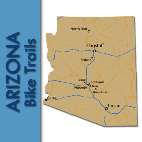
TRAILS
Flagstaff, Arizona
Buffalo Park Loop (Nate Avery Trail)
Location: Flagstaff, AZ Length: 2 miles Times: N/A Fees: N/A
Parking: Buffalo Park at 2400 North Gemini Drive Type: Dirt/gravel greenway
For more information on the Buffalo Park Loop Trail Click Here
Karen Cooper Trail (Rio North Trail)
Location: Flagstaff, AZ Length: 3.6 miles Times: N/A Fees: N/A
Parking: Thorpe park, Wheeler Park, & ballfields at Aztec St. Type: Gravel greenway
Route 66 Trail
Location: Flagstaff, AZ Length: 4.2 miles Times: N/A Fees: N/A
Parking: Visitor Center on Route 66 Type: Concrete rail-trail
For more information on the Route 66 Trail Click Here
Schultz Creek Trail
Location: Flagstaff, AZ Length: 8 miles Times: N/A Fees: N/A
Parking: Parking area along Schultz Pass Road Type: Mountain biking
Sinclair Wash Trail
Location: Flagstaff, AZ Length: 5.7 miles Times: N/A Fees: N/A
Parking: Fort Tuthill Park Type: Dirt path
For more information on the Sinclair Wash Trail Click Here
Tunnel Springs Trail
Location: Flagstaff, AZ Length: 1.9 miles Times: N/A Fees: N/A
Parking: Along Street of Adirondack Ave. Type: Dirt path / Mountain biking
For more information on the Tunnel Springs Trail Click Here
North Rim, Arizona
Rainbow Rim Trail
Location: North Rim, AZ Length: 19 miles Times: Late spring to fall
Fees: None Type: Mountain biking
This remote trail is located within the Kaibab National Forest. While it is remote with no service stations within miles, it has breathtaking views along the North Rim of the Grand Canyon. A great place for your next ride and maybe even your next camping adventure!
For more information on the Rainbow Rim Trail Click Here
Peoria, Arizona
New River Trail
Location: Peoria, AZ Length:16.5 miles Times: 6am - 10:30pm Fees: N/A
Parking: Rio Vista Community Park (8866 W. Thunderbird Rd.) Type: Paved
Phoenix, Arizona
Arizona Canal Trail
Location: Phoenix, AZ Length: 69 miles Times: N/A Fees: N/A
Parking: Thunderbird Paseo Park (Glendale) & Granada Park (Phoenix) Type: Paved
The Arizona Canal Trail proves to be one of the longest trails in Maricopa County, spanning from Peoria to Scottsdale. This trail follows the Arizona Canal on both sides and connects to many other trails along the way. This trail is definitely a great trail to help you get out and explore the Phoenix area!
Phoenix Sonoran Preserve (Apache Wash Loop)
Location: Phoenix, AZ Length: 5.6 miles Times: 5am - 11pm Fees: N/A
Parking: Parking at trailheads Type: Mountain biking
State Route 51 Trail
Location: Phoenix, AZ Length: 5.2miles Times: N/A Fees: N/A
Parking: Lot located NW corner of Sweetwater Ave. and 36th St. Type: Paved
Queen Creek, Arizona
Queen Creek Wash Trail
Location: Queen Creek, AZ Length: 4.7 miles Times: N/A Fees: N/A
Parking: Desert Mountain Park (22201 S. Hawes Road) Type: Paved greenway
For more information on the Queen Creek Wash Trail Click Here
Scottsdale, Arizona
Gainey Ranch Road Trail
Location: Scottsdale, AZ Length:1.1 miles Times: Sunrise to 10:30pm Fees: N/A
Parking: Scottsdale Rotary Park (7959 E. Doubletree Ranch) Type: Paved
Indian Bend Wash Trail
Location: Scottsdale, AZ Length: 6.2 miles Times: N/A Fees: N/A
Parking: Eldorado Park (2311 N Miller Rd.) & Chaparral Park Type: Paved
Pemberton Loop
Location: Scottsdale, AZ Length: 15 miles Times: 6am - 8pm Fees: $2+
Parking: 16300 McDowell Mountain Park Drive Type: Mountain biking
For more information on the Pemberton Loop Trail Click Here
For more information on park entry fees Click Here
Sedona, Arizona
Templeton Trail
Location: Sedona, AZ Length: 7.4 miles Times: Year-round Fees: $5
Parking: At trailhead off of Back-O’Beyond Rd. Type: Mountain biking
The Templeton Trail is a trail in Sedona known for its views of the Cathedral Rock. This trail remains unshaded, so use caution in the summer because it can get very hot! Templeton Trail is great trail for all skill level riders.
For more information on the Templeton Trail Click Here
Tempe, Arizona
Rio Salado Pathway
Location: Tempe, AZ Length: 12 miles Times: N/A Fees: N/A
Parking: Tempe Park Beach & Riverview Park (in Mesa) Type: Paved
For more information on the Rio Salado Pathway Click Here
Western Canal Path
Location: Tempe, AZ Length: 22 miles Times: N/A Fees: N/A
Type: Paved greenway
The Western Canal Path is just one of the many trails around the Phoenix area. It follows along the canals as it goes from Tempe, along the Chandler/Mesa border, and through Gilbert. There are multiple parking areas including: McQueen Park in Gilbert, Palo Verde Park in Mesa, and Kiwanis Park in Tempe. The Western Canal Path also connects to the Kyrene Canal Path at midpoint and on the Consolidated Canal Path on the east.
For more information on the Western Canal Path Click Here
Tucson, Arizona
50-Year Trail(Golder Ranch)
Location: Tucson, AZ Length: 8.6 miles Times: 5am to 10pm, Year-round
Fees: $7 per vehicle Parking: Catalina State Park Type: Mountain biking
For more information on the 50-Year Trail Click Here
Golf Links-Aviation Path
Location: Tucson, AZ Length: 9.4 miles Times: N/A Fees: N/A
Parking: Freedom Park (5000 E. 29th St.) & take spur trail to main trail Type: Paved
Rillito River Park Trail
Location: Tucson, AZ Length: 21.8 miles Times: Dawn to dusk
Fees: N/A Type: Paved greenway
Parking: Eastern Terminus West of N. Craycroft Rd. & Brandi Fenton Memorial Park
Sweetwater Preserve
Location: Tucson, AZ Length: 10 miles Times: Dawn to dusk Fees: N/A
Parking: 4001 North Tortolita Road Type: Mountain biking
For more information on the Sweetwater Preserve Click Here
Yuma, Arizona
Yuma Crossing Bike Path
Location: Yuma, AZ Length: 1.55 miles Times: N/A Fees: N/A
Parking: Off of N. Gila St. & Joe Henry Memorial Park Type: Paved
Wondering where to find great bike trails in your state? Keep checking in as we update our blog weekly with new state information.